
![]()
New link about Wartling, click here
In around 1959 the RAF transferred a number of radar stations from Fighter Control to the Military Area Radar Control Service. These radars overcame a shortage of high level long range radar for military air traffic control use for the RAF and Royal Navy but also for civil area control. Very soon the first civil sectors were opened within some of these Air Traffic Control Radar Units and they became known as JATCRUs (Joint ATCRU). The initial national high level joint radar network was based on Ulster, Southern, Mersey and Border Radars.

Civil Cell Operations Room. Detailed view showing left to right, Twin Radar, Edge – Lit Traffic Display, Sector Radar and further Traffic Display. August 1959. The beacons on the edge lit board include Hurn, Hastings, Dunsfold and Seaford and above them Woodley, Epsom and Mayfield. the far information board has info on Gatwick and Heathrow.
Before the creation of this network, there had been an extensive network of military radar sites around the UK. By 1945 the entire coast of the UK was protected by the Chain Home early warning network. In addition there was a network of radar stations known as Ground Control Interception (GCI) Units that we would now think of as Fighter Control stations. The initial JATCRUs were all former GCI stations but stories emerged of civil ATCOs working within at least one military radar unit known as Antrobus and located near Warrington at RNAS Stretton (HMS Blackcap). Antrobus controllers provided a regional radar service over the NW of England. By the time the national JATCRU network was established the task had transferred to Mersey Radar at Hack Green.
Just recently a new and diverse archive has been sent in to atchistory, by the family of Arthur Childs. Arthur was a former Senior Air Traffic engineer at LATCC. Included in his archive wa a clipping, I think taken from “Airway”, from October 1992. The clipping was written by Jean Harris, a former ATCA and Briefing Officer who was employed at Uxbridge Area Control Centre when first airway Green One West came into use. Jean reminded us that there was a radar aerial at Beachy Head that was connected to RAF Wartling GCI Radar Station located on the nearby Pevensey Levels.

(Type 80 radar on Beachy Head – there is also one of the height finding radars visible just to the right of the Type 80 aerial)
This was used by civil ATC staff at Wartling to provide radar coverage over airway Red One East for SATCC (in the early 60s?). Scanning through the archive we also picked up that fact that Bert Harding was one of the ATCOs who served at Wartling. Bert, a formal military and civil flying boat pilot, also worked at Bovingdon, CATC, Sopley, SATCC and HQ. He retired as C watch Supervisor at LATCC in 1977.
So now we have two pre JATCRU joint radar units, Antrobus and Wartling, were there any more I wonder?
(For all the operational youngsters out there, all the above long gone units: Antrobus, Hack Green, Ulster, Southern, Mersey and Border Radars, Uxbridge and SATCC all feature as blog posts on this site as do successor units like Lindholme and Eastern).
For more on RAF Wartling see http://www.subbrit.org.uk/rsg/sites/w/wartling_r7/)
and
http://www.bushywood.com/history/RAF_Wartling_Radar_Stations_Sussex_World_War_Two.htm
The above was published in Transmit’s Summer 2016 issue. Below are some memories of Wartling Radar sent in by Roy Bradbury.
“The radar scanners as you say were at WARTLING, which was located on the higher ground to the North of Pevensey Levels, although I neither had the transport nor the interest to explore further at the time. Sufficient to say from the late 50’s until the mid sixties the scanners were visible from our house a further six miles inland at a place called Netherfield when I was between 10 and 15 years old. In the distance was Beachy Head and at sea the shipping channels were not clearly defined, as they are today, and both coasters and ocean going vessels cut through Pevensey Bay and cleared Beachy Head by only a mile or so.
In the early seventies I met a controller called Ron Hooper, who had also served at Wartling, and recalled an event whereby severe electrical storms had so disrupted Heathrow Radar that SATCC at WARTLING had been called upon to provide a rudimentary service for Heathrow. Presumably less regulation and more seat of the pants initiative existed in those days. Maybe they were just a bit more cavalier, maybe the story grew more exciting as the years faded but he was certainly an interesting controller to work alongside. Just wish I could recall more of his tales of the unexpected but never thought to write them down.”
and a new photo from Barry Davidson.
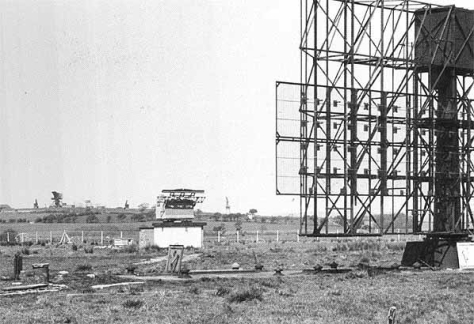
experts will no doubt correct me, but I think its a type 7 on the right and that I can see a Type 80 and two Yypes 14s (High and Low?) plus 3 height finders. I’m not sure about the beasty in the centre foreground. but possible a concrete plinth and IFF array.

Pure speculation but I wonder if the T80 at Beachy Head was transferred to Wartling where I saw it in 1957.
Beachy Head was a popular tourist area and the wisdom of picnickers being exposed to 2,500 watts of microwave radiation at least 4 times per minute may have made the move necessary.
LikeLike
Any more JATCRUs; could you include Ash?
A few miles south of Manston it was used extensively for Air Defence and for watching traffic on ‘Red 1/Blue 29’ but I think it closed in the mid/late’70s when Debden Radar came on line.
Re-opened possibly for Air Defence again in about 1988 (I met some of the guys stationed at Ash when I was at easter ATC camp at Manston) but closed again when the ‘cold war’ started to thaw due to Gorby.
There was also a low level ‘JATCRU’ at Manston called ‘Kent Radar’which operated services for cross channel traffic; it was a NATCS/NATS unit operated jointly with RAF Manston Approach with defined upper and lower limits, the lower one being something like 500ft agl I think.
LikeLike
Kent radar is already on here. I’ll have a look at Ash
LikeLike
I had a look at RAF Ash but can’t find any evidence of an ATC function so neither an ATCRU nor a JATCRU it appears.
LikeLike
In the mid ’60s, on a school visit to Bradwell Bay nuclear power station, we passed a large radar scanner on a hill near a town in Essesx which according to my map was South Woodham Ferrers.
Was this another unknown radar station or was it (I suspect) a Marconi test site which sometimes provided a radar service using the callsign ‘Tango Radar’?
LikeLike
Hi Terry,
That was a Marconi Radar Test Development Site based at Bushy Hill, Woodham Ferrers. Based on the year you supplied, that was likely to be a Type 80, but a development model with the L-band scanner.
LikeLike
In 1957 when I would have been 8 years old, our summer holiday was in Hastings. One day we took a bus along the coast to Eastbourne and I remember seeing a big rectangular radar scanner on a small hill which would have been Wartling.
10 years later on a school visit to to the Royal Greenwich Observatory at Herstmontceaux, I looked for this radar scanner but it had gone.
In early 1973 we visited Sopley as part of our Area Radar course and on seeing the Type 80 there, I mentioned the similar one I had seen at Wartling and was told this was the same one. Wartling had apparently been closed due to flooding and the Type 80 moved to Sopley.
LikeLike
The radar head in the last photo is an IFF mk10 and the height finders are probably FPS 6s
LikeLike